SincpacC3D
General Information
Command Summary

ProfileStationing
|
SincpacC3D
General Information
Command Summary
ProfileStationing |
Description
The ProfileStationing command creates a profile based on the length of profile. This provides a method of stationing a pipe distance for a profile. This method of stationing is often used for pipe line design. Once created the elevation of the profile maybe utilized in the profile bands to represent the profile length as a station value or utilize it in the ProfileStationingReplaceLabels command.
This command contains options for naming the profile, providing a description, profile style, and a layer.
Usage
Run the ProfileStationing command and select the desired profile to extract a profile to represent the length of the profile. The following dialog box will then appear:
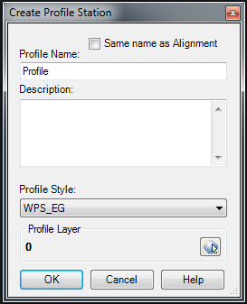
Type in the desired name of the new profile. Enter a description and select a profile style and profile layer.
Once you have all settings the way you want them, hit OK. The profile will be created.
See Also
CAPFeature is "Create Alignment and Profile from Feature Line". Creates an alignment and profile from an existing Feature Line or Survey Figure. Excess PVIs may also be pruned with a setting similar to the one in CAPSurface.
Creates an alignment and profile from an existing polyline and an existing surface. The surface is sampled at the specified interval, and/or at enough intervals to keep the error within a specified tolerance.
Add a lowering to an existing finish ground profile. Particularly useful for waterlines.
Creates alignments from polylines. Arcs in the polyline are converted to Free Curves, if possible.
Display Points by Station and Offset, as measured along an Alignment. Results are displayed on screen and may also be written to a file.
Prune PVIs from a Finished Ground profile.
Convert an Existing Ground profile (sampled from a surface) to a Finish Grade profile (with editable geometry points).
