SincpacC3D
General Information
Command Summary

CreatePointsFromLabels
|
SincpacC3D
General Information
Command Summary
CreatePointsFromLabels |
Description
The CreatePointsFromLabels command can be used to create Civil-3D Points at the exact location and elevation of Surface Elevation Labels found in a drawing.
Note: This command is not available in the 2008 and 2009 versions.
Usage
Type CreatePointsFromLabels at the command line to call up the Settings dialog shown below:
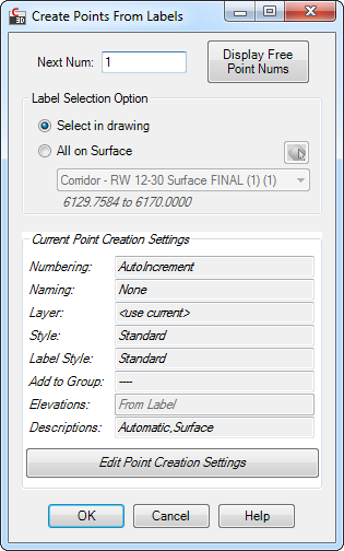
The lower portion of the dialog box contains the Point Creation Control, which summarizes the current Point Creation Settings. You may adjust these settings by clicking the "Edit Point Creation Settings" button, which will take you to the Point Creation Dialog. Note that the Elevation settings are not available for this command, since the generated Cogo Points take their elevations directly from the selected labels.
Label Selection Options
Controls the way labels on which to set points are selected.
Select in Drawing |
The user must manually select each label to use. |
All on Surface |
All Surface Elevation labels for the specified surface will used. |
See Also
Create Civil-3d Points in a variety of ways.
Find and Replace text in the Raw Description of Points.
Displays a list of available point numbers in the command window.
Select a point and see a list of all point groups it belongs too. Also allows you to remove the point from selected groups.
Set points on all lot corners in the selected parcel(s).
Move points in the drawing. Points are only moved horizontally, with no datum adjustment, and may be selected by Point Group.
Set the next point number for point creation.
Displays an inverse between two points, containing the Horizontal and Slope distances, the bearing, the slope and grade, and the Delta X, Delta Y, and Delta Z values between the points.
Create elevated offset points along Feature Lines, Survey Figures, Parcels, Polylines, or 3D-Polylines for survey stakeout.
Displays a list of used point numbers in the command window.
Zoom to a Cogo Point by typing the Point Name or Number in the command window.
