SincpacC3D
General Information
Command Summary

PtInv
|
SincpacC3D
General Information
Command Summary
PtInv |
Description
The PtInv command displays an inverse between two points. The inverse contains the Horizontal and Slope distances, the bearing, the slope and grade, and the Delta X, Delta Y, and Delta Z values between the points. It can also maintain a running total of successive distances, adding the value of each measurement to the running total.
The PtInv command has three different modes of operation:
The "Single", "Continuous", and "Multiple" keywords may be used to switch between the three modes at any time.
You may also type the point number for a Cogo Point at the prompt, instead of selecting a point on-screen with the cursor.
Usage
Type PtInv at the command line. You will be prompted to select two points in the drawing. You will then see output similar to the following:
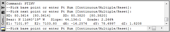
The values in the output are:
The precision for the distance, slope/grade, and elevation values may be configured from the OPTIONS Tab. These settings may optionally be configured so that they are remembered on a per-drawing basis, in order configure different drawings to have different precisions. When using per-drawing settings, you may configure the settings in your drawing templates, to control the settings in newly-created drawings. Otherwise, newly-created drawings will take on the last-selected settings.
The values in square braces are running totals. The "Reset" keyword may be used to reset these values at any time.
After starting the command, continue selecting points in response to the prompts. You may also key in a Cogo Point number, instead of selecting a point on-screen. The "Single", "Continuous", and "Multiple" keywords may be used to switch between the three modes. To cancel the command, right-click or hit the ESC key.
See Also
Inverse between Cogo Points.
Find and Replace text in the Raw Description for points.
Displays a list of available point numbers in the command window.
Move points in the drawing. Points are only moved horizontally, with no datum adjustment, and may be selected by Point Group.
Set the next point number for point creation.
Add and/or remove selected Civil-3D Points to/from one or more existing Point Groups.
Manually create points with a variety of options, including getting the elevation from the pick point.
Displays the angle formed by three points. The angle dimension is displayed as an interior angle, an exterior angle, and a deflection angle.
Displays the arc distance, radius, and delta (central) angle of the arc segment defined by picking three points. Points may also be specified by keying in point numbers at the prompt.
Rotate Civil-3D Point Markers.
Rotate Civil-3D Point locations, with an option to select by point group.
Displays a list of used point numbers in the command window.
Zoom to a Cogo Point by typing the Point Name or Number in the command window.
