SincpacC3D
General Information
Command Summary

CreateSectionAlignmentLines
|
SincpacC3D
General Information
Command Summary
CreateSectionAlignmentLines |
Description
CreateSectionAlignmentLines allows the user to create alignments from point groups or selected polylines to represent river sections. The command intent is to allow the export of hydrology information for a hydrology study, such as HEC-RAS, MIKE 11, or ISIS, without the use of an existing ground surface.
Usage
Type CreateSectionAlignmentLines at the command line (or run the command from the Ribbon). A dialog box comes up.
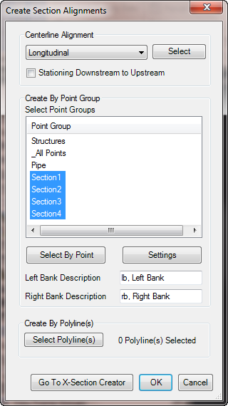
Centerline Alignment
Select the alignment representing the river centerline. Next select if the stationing direction of the alignment. The start stationing of the section alignments will be determined based on the this value.
Create by Point Groups
Select the point groups to use to create the sections. A section will be created for each of the point groups selected. The points contained in the point group will be connected using a least squares best fit. The point group desired may be selected using the Select By Point button. The point group will be selected and selected in the list.
The settings button opens a dialog box where the settings used to create the alignment may be set. The settings are used for both the alignments created by Point Group and created by Polylines.
The Left Bank and Right Bank descriptions are used to find the direction of the section alignment. The values are optional.
Create by Polylines
To use the Select By Polyline(s) option select the desired polyline from the drawing.
Go To X-Section CreatorIf selected the section alignments will be created and then the command will go directly to the PointsToProfile command where profiles will be created from the points contained in the point group.