SincpacC3D
General Information
Command Summary

SPParcelInverse
|
SincpacC3D
General Information
Command Summary
SPParcelInverse |
Description
The SPParcelInverse command gives the user a method report the 2d Inverse and/or Mapcheck of the perimeter of a Parcel, Polyline, Featurline, or Figure.
Usage
Type SPParcelInverse at the command line. You will be presented with a palette in which the Inverse or Mapcheck data will be displayed. At the top of the palette are default settings in use, which may be changed at any time while the palette is open. The default settings are obtained from the drawing's Parcel Ambient Settings (there other settings which we don't allow you to alter in this dialog, but are honored by the command, such as the Drop Leading Zeroes for Degrees). If a setting is altered while the data is displayed for an object, the data will immediately update to reflect that change. Similarly, you may toggle between Inverse and Mapcheck at anytime. For Parcels, the direction to process the segments initially is obtained from drawing's "Process counter-clockwise" setting of the Parcel Analysis setings, all other objects use the direction in which they were created. Once the inverse, or mapcheck, data is displayed, you may reverse the direction the segments are processed by pressing the Reverse button. Note that the mapcheck option uses the displayed values to calculate the error of closure, whereas the Inverse option uses the object's true coordinates. When selecting a parcel, the ParcelAreaLabel must be selected, all other objects you may select directly.
The following image shows the results of selecting a Parcel.
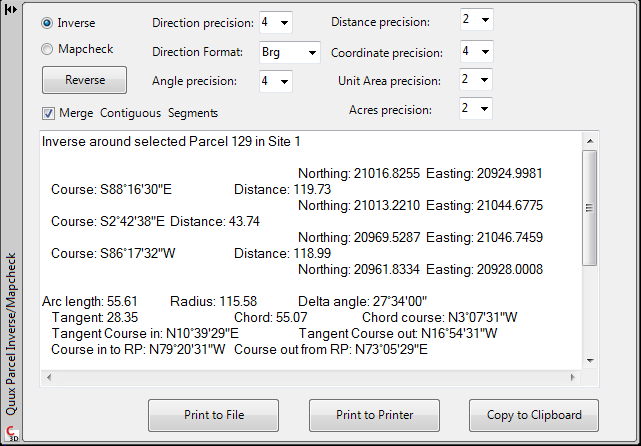
As you can see, there are buttons along the bottom of the teXt window to send the data to either a file, a printer, or the clipboard. This could be handy for pasting the results into your favorite text editor or word processor.
Note that this palette may be set to autohide, but it may not be closed unless the command is terminated at which point it will automatically close.
See Also
Method to gather Area statistics for a Site, or Sites, and the Parcels contained within them.
