SincpacC3D
General Information
Command Summary

User Defined Properties
|
SincpacC3D
General Information
Command Summary
User Defined Properties |
Some Sincpac-C3D commands are capable of writing values to User Defined Properties (UDPs) in your drawing.
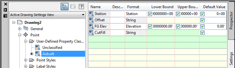
In order to use these features, you must first create a User Defined Classification that defines your new attributes. An example can be seen below:
Property Types
For some UDPs, you can gain additional formatting options in your Label Styles by selecting the appropriate type. In the image above, the "Station" parameter is specified as a Station property, and the "FG Elev" property is specified as an Elevation property.
If a property will contain a mixture of letters and numbers, it should be declared as String properties. For example, in the image above, the "Offset" and "CutFill" properties are declared as Strings. This is because an Offset may be configured to have a strings like "Lt" and "Rt", or "L" and "R", etc, and a CutFill might have a format like "C-0.00". On the other hand, if you configure your Offset and CutFill so that they are digits only (with no letters), you can use a Double property, which will give you additional formatting options in Label Styles.
Assigning a Classification
Very Important: Before a UDP can be used by a Sincpac-C3D command like DLPoints or DLCoordConvert, it must be assigned to the relevant Cogo Points. This is accomplished by placing the Cogo Points into a Point Group, and adjusting the "Classification" for the Point Group as shown in the image below:
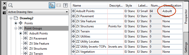
You can also change the Classification on the Detail pane of the Point Group Properties (right-click on the Point Group, select Properties). However, you may encounter a bug when doing this. At least as of the Civil 3D 2011 release, C3D will crash if a Point Group already has Cogo Points added to it, and you attempt to change the Classification via the Summary tab. However, this bug is not triggered when changing the Classification from the Detail pane of Toolspace, as shown in the image above. So that option is safer than changing the Classification from the Summary tab of the Point Group Properties.
See Also
Allows User Defined Properties on Cogo Points to be automatically populated with coordinates in alternate Coordinate Systems.
Manages dynamic links between Cogo Points and other Civil-3D entities. This allows the elevations of Cogo Points to change dynamically whenever the "master" object changes. Similarly, the description may be set to display the Station/Offset of the point, and the Station/Offset will also dynamically respond to changes in the model. The "master" object may be a Surface, a Profile, an Alignment, or a linear entity such as a Feature Line, Survey Figure, Polyline, or 3D-Polyline.
