SincpacC3D
General Information
Command Summary

PLProfile
|
SincpacC3D
General Information
Command Summary
PLProfile |
Description
The PLProfile command can be used to create a profile from a polyline in a profile view. It is useful for those cases when you receive linework from someone who is not using Civil-3D, and you need to create a Civil-3D Profile from a "dumb" profile view. Starting with Sincpac-C3D v3.8 you may also select a Featureline, either in plan or projected into the profileview, which can be handy for existing roadside ditches, eop, etc.
Unfortunately, the current version of this routine cannot handle vertical curves. So the polyline used to create the profile should extend from PVI to PVI. Then once the Profile is created from PVI to PVI, go back and add the vertical curves using the normal Civil-3D Profile editing commands.
Usage
Before starting this command, make sure the linework you want to use has been joined into a continuous polyline, and is placed in the correct location on an appropriately-sized Profile View. Note that you may need to edit the vertical exaggeration in the Profile View Style.
Once you have a correctly-placed polyline on a Profile View, run the PLProfile command, and select the Profile View. Or, you may select the Profile View, right-click, and select "Create Profile from Polyline" from the shortcut menu. Then select the polyline or featureline you wish to use for creating the Profile. The following dialog box will then appear:
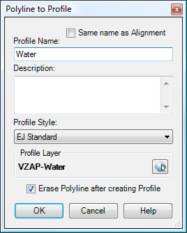
Set the various options as-desired, and click the OK button to create the Profile. The Profile is created without labels, so you will then need to apply the desired Label Set.
Note that you may select a layer for the new Profile to be created on, you may specify a suffix and/or a prefix. Clicking on the symbol in the "Profile Layer" box calls up the following dialog:
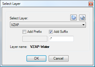
A new layer will be created by adding the suffix or prefix to the name of the selected layer. If you include an asterisk (*) in either the Suffix or Prefix, it is replaced with the name of the Profile. The actual name of the layer, after applying any suffixes and prefixes, is shown in bold type underneath the prefix and suffix text boxes. This is the name of the layer that the Profile will actually be created on, and the layer will be created if necessary. If a new layer is created, it is created with all the same attributes as the selected layer - color, lineweight, plot style, etc.
In the example above, the VZAP layer is selected, and a suffix is specified. When applying the suffix, the asterisk is replaced by the Profile Name, and the result is VZAP-WATER. If it doesn't already exist, the VZAP-WATER layer is created with all the same attributes as the VZAP layer.
Example
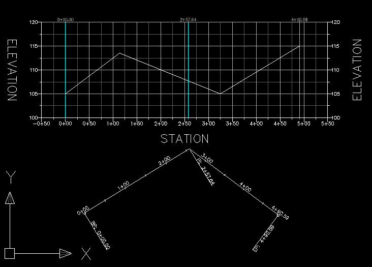
The diagram below shows a Civil-3D Alignment with Profile View. The white line drawn across the Profile View is a simple polyline.
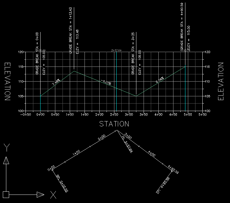
If we now select the Profile View, right-click, and select "Create Profile from Polyline", we are prompted to select the polyline. We then see the dialog box shown in the "Usage" section above. After configuring the settings as-desired and hitting OK, the polyline is converted into a Civil-3D Profile
However, this Profile contains no labels. To label it, we now need to select it, right-click, and select "Edit Labels...". We can then apply a Label Set, getting a result that looks something like that shown below:
For some more details about the label issue, take a look at these notes on the profile issues that exist with the current version of Civil-3D.
See Also
CAPFeature is "Create Alignment and Profile from Feature Line". Creates an alignment and profile from an existing Feature Line or Survey Figure. Excess PVIs may also be pruned with a setting similar to the one in CAPSurface.
Creates an alignment and profile from an existing polyline and an existing surface. The surface is sampled at the specified interval, and/or at enough intervals to keep the error within a specified tolerance.
Creates alignments and profiles from a variety of objects, including polylines, 3D-Polylines, Feature Lines, and Survey Figures. Various pruning options may be used when creating the alignment and profile.
Add a lowering to an existing finish ground profile. Particularly useful for waterlines.
Creates alignments from polylines. Arcs in the polyline are converted to Free Curves, if possible.
Display Points by Station and Offset, as measured along an Alignment. Results are displayed on screen and may also be written to a file.
