SincpacC3D
General Information
Command Summary

HashPoly
|
SincpacC3D
General Information
Command Summary
HashPoly |
Description
The HashPoly command creates hash marks at PIs, PCs, PCCs, and PRCs along polylines, Feature Lines, Survey Figures, or Parcels.
Note that this command works on a large variety of linear objects, including Parcels. However, due to the way Parcels are defined, you will usually get better results with those if you use the HashParcel command instead.
The hash marks created by the HashPoly command are actually Civil-3D Point objects, so you must define a Point Style to be used for this command. Include this point style in your Drawing Template(s), so that this command is always ready-to-run in any drawing.
Usage
Type HashPoly at the command line and select items on the screen. Right-click or hit ENTER when you are done. You may also enter "SE" to change the Hash Settings.
The HashPoly command will ALWAYS place a hash mark at PCs, PCCs, and PRCs. It will also place hash marks at angle points if the deflection at the PI is less than the Max Deflection Angle specified in the Hash Settings.
Example:
Consider the figure below.

It is not readily-apparent where all of the various horizontal geometry points are located. The image below contains the same image, but this time with circles on every horizontal PI.
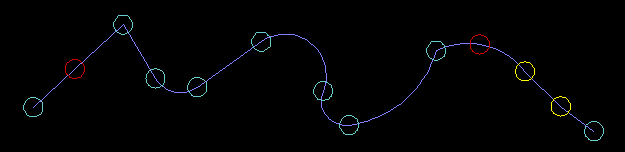
The yellow circles indicate PIs that have very small deflections, less than the Max Deflection Angle specified in the Hash Settings. Since they are less than the Max Deflection Angle, they will receive hash marks.
The red circles indicate a PI that is a Point on Line (POL) or Point on Curve (POC), as defined in the diagrams in the Hash Settings.
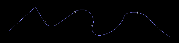
Therefore, if run the command while "Hash POLs and POCs" is selected, we will get the following results:
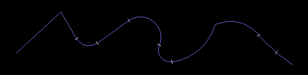
However, if we run the command while "Hash POLs and POCs" is NOT selected, we do not get hashes at the PIs marked by the red circles, as shown in the following diagram:
See Also
Create hash marks at PIs, PCs, PCCs, and PRCs for all Parcels in the selected Sites.
Creates offsets with varied distances around parcels. Useful for setbacks and utility easements that run at differing distances around the lot, such as 7' along the front, 5' along the sides, and 10' along the rear.
